EO:EUM:DAT:MSG:HRSEVIRI
 High Rate SEVIRI Level 1.5 Image Data - MSG - 0 degree
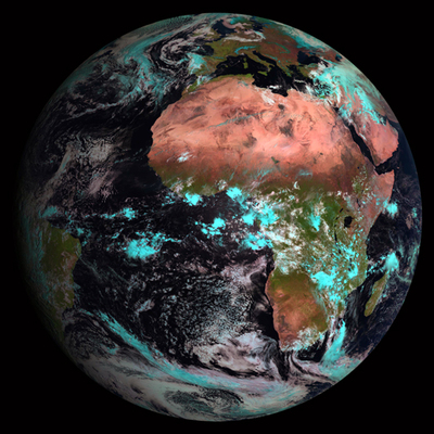
Rectified (level 1.5) Meteosat SEVIRI image data. The data is transmitted as High
Rate transmissions in 12 spectral channels. Level 1.5 image data corresponds to the
geolocated and radiometrically pre-processed image data, ready for further processing,
e.g. the extraction of meteorological products. Any spacecraft specific effects have
been removed, and in particular, linearisation and equalisation of the image radiometry
has been performed for all SEVIRI channels. The on-board blackbody data has been processed.
Both radiometric and geometric quality control information is included.
Images are made available with different timeliness according to their latency: quarter-hourly
images if latency is more than 3 hours and hourly images if latency is less than 3
hours (for a total of 87 images per day).
To enhance the perception for areas which are on the night side of the Earth a different
mapping with increased contrast is applied for IR3.9 product. The greyscale mapping
is based on the EBBT which allows to map the ranges 200 K to 300 K for the night and
250 K to 330 K for the day.
A selection of single channel data are visualised in our EUMETView service.
Satellite: MSG
Instrument: SEVIRI
Temporal Extent: 2004-01-19 -
now
Orbit Type: GEO
Data Policy: NRTLicense, GeneralLicense
Browse productsShow this collection's OpenSearch Description Document
