EO:EUM:DAT:0407
 OLCI Level 2 Ocean Colour Full Resolution - Sentinel-3
OLCI (Ocean and Land Colour Instrument) NRT and NTC ocean colour geophysical products
at full resolution (300m at nadir). Level 2 OLCI marine products have changed substantially
with the introduction of baseline collection 004 (BC004), as noted below. Level 2
marine products include the following:
- water-leaving reflectances (BC003) or remote sensing reflectances (BC004) in 16
bands, Oa??_reflectance (Baseline Atmospheric Correction (BAC:BC003) or Ocean Colour
Standard Atmospheric Correction (OC-SAC: BC004) algorithm, bands: 400, 412, 442, 490,
510, 560, 620, 665, 674, 681, 709, 754, 779, 865, 885, 1024 nm);
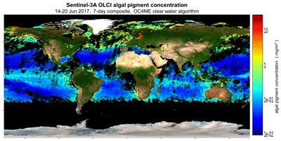
- algal pigment concentration in clear waters, chl_oc4me (BAC: BC003 and maximum band
ratio algorithm, log10 scaled) or chlor_a (OC-SAC:BC004 and blended optical water
type determined algorithm, log10 scaled);
- inherent optical properties (IOPs) and optical water classes, acdm_443/acdom_443/anw_443/aphy_443/bbp_443/bbp_slope/OWC
and flags iop_flags (OC-SAC:BC004);
- fluorescence peak height, FPH (OC-SAC:BC004);
- diffuse attenuation coefficient of downward irradiance at 490 nm, kd_490 (BAC:BC003
and OC-SAC:BC004, log10 scaled);
- instantaneous photosynthetically active radiation, PAR (BAC:BC003 and OC-SAC:BC004);
- aerosol optical thickness and aerosol Angstrom exponent at 865nm, T865 and A865,
respectively (BAC:BC003 and OC-SAC:BC004)
- algal pigment concentration in complex waters, chl_nn (neural net algorithm, log10
scaled);
- total suspended matter concentration in complex waters, tsm_nn (neural net algorithm,
log10 scaled);
- cdm absorption at 443 nm in complex waters, ADG443_nn (neural net algorithm, log10
scaled);
- integrated water vapour column, iwv (1D-Var algorithm).
The geophysical products are accompanied by uncertainty estimates. Pixel classification,
quality and science flags, as well as meteorological, geometry and geolocation data
at tie points are provided.
- All Sentinel-3 NRT products are available at pick-up point in less than 3h
- All Sentinel-3 Non Time Critical (NTC) products are available at pick-up point in
less than 30 days.
Sentinel-3 is part of a series of Sentinel satellites, under the umbrella of the EU
Copernicus programme.
Satellite: Sentinel-3
Instrument: OLCI
Temporal Extent: 2021-02-14 -
now
Orbit Type: LEO
Data Policy: Copernicus
Browse productsShow this collection's OpenSearch Description Document
