EO:EUM:DAT:0152
 AVHRR Polar Atmospheric Motion Vectors Climate Data Record Release 2 - Metop-A and
-B
AVHRR Polar Atmospheric Motion Vectors Climate Data Record Release 2 - Metop-A and
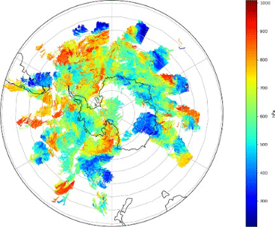
-BTropospheric satellite winds at all heights below the tropopause in the polar regions
(latitudes higher than 45º), derived from the infrared channel of the Metop AVHRR
instrument.
This is the second release of the polar atmospheric motion vectors data record. Data
are accessible from the EUMETSAT Data Centre. This uses the version 3.1.1 of the EUMETSAT
operational algorithm and forecast from ERA-Interim reanalyses as auxiliary data.
The data record includes products generated using IR images (channel 4) taken from
the AVHRR/3 imager on-board Metop-A and Metop-B polar satellites. Polar AMVs are derived
using 2 AVHRR orbits leading to one product every 100 minutes. Each product contains
several wind vectors with their associated speed, direction, height, and several quality
indicators. The dataset covers the period from 1 March 2007 until 31 December 2017
for Metop-A, and from 24 April 2013 until 31 December 2017 for Metop-B.
The coverage boundaries are polar caps poleward of 45 degrees. The dataset is available
in two formats: the EUMETSAT EPS native format and the BUFR format.
See Related Products tab for Release 1.
This is a Thematic Climate Data Record (TCDR) produced for the Copernicus Climate
Change Service.
Satellite: Metop
Instrument: AVHRR
Temporal Extent: 2007-03-01 -
2017-12-31
Orbit Type: LEO
Data Policy: NoConditions
Browse productsShow this collection's OpenSearch Description Document
